One of the more esoteric features of the FDO API is the ability to apply schema overrides via an XML configuration file.
Unfortunately this feature is not really well documented, so this blog post will hopefully make it much easier to understand how to use this feature.
What are Schema Overrides?Schema Overrides allow you to define or override the following aspects of a FDO data source or MapGuide Feature Source:
- The spatial contexts for this data source
- The logical schema (schema/class/properties) of this data source
- The mapping of this logical schema to the underlying physical storage (class -> table, property -> column)
This information is specified in a XML-based configuration file
How are Schema Overrides used?For FDO providers like ODBC, there is no actual concept of:
- Geometry properties
- Spatial Contexts
In this case, schema overrides can be used to "declare" point geometry properties (based on X/Y/Z columns) and what spatial context these points represent. The ODBC feature source table editor in MapGuide Studio/Maestro is a specialized editor of this kind of schema overrides.
Another use, which I think is not quite known is to override how FDO interprets the tables and views in your database, especially views.
A practical exampleOne of the common needs in any presentation of data is the ability to have one set of data linked to another set of data. In MapGuide, Feature Joins can be used to achieve this effect.
But the performance of Feature Joins can range anywhere between fair and excruciatingly slow (especially when themes are involved), and as such I generally do any of the following:
- Pre-join the related bits of data before loading it into MapGuide
- If both sets of data come from the same database, do the join at the database level and encapsulate the result in a view.
Our example covers point #2.
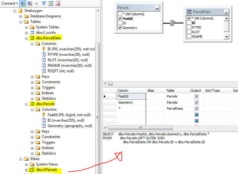
Consider the following SQL Server database:

Suppose we want to have a view (called
VParcels) that represents the
Parcel tables and any related records from the
ParcelData table. You would normally do a join similar to this:

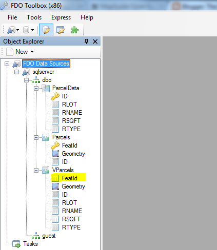
Now if we look at this database through FDO Toolbox, you'll now see that our view is represented as a feature class:

But we have a problem, if we make a layer off of this we can't select any objects on it. Look at the ID property:

It isn't an identity property. If we create a layer from this feature class we won't be able to select objects on it because identity properties are the mechanism by which MapGuide knows which particular objects have been selected. In fact, 90%-95% of most problems where layers aren't selectable can be boiled down to a violation of this one basic rule:
No identity properties = unselectable layersSo now we know the problem, how can we fix it? We could index this view, by applying a
unique clustered index (the only valid index that can be applied to a SQL server view, other DBMSes may be different), FDO (for SQL Server) will interpret the index as the identity properties.
But a unique clustered index requires that the view only use
inner joins which may be a problem especially if you want to show parcels that have no related records (ie. a
left outer join).
Enter FDO Schema Overrides to the rescue.
FDO Toolbox 0.9.6 introduced a new command that allows you to dump the default schema mapping to an XML file. What we will do is dump a default XML configuration, and then do the following:
- Edit this configuration file
- Test this configuration in FDO Toolbox
- Loading this configuration file to MapGuide
- Testing this configuration in MapGuide
So it goes without saying, you'll need
FDO Toolbox v0.9.6 or later to do this.
If you right click our SQL Server connection, you will see a new
Dump Schema Mapping command on the context menu. This command will create an XML configuration file containing the following information:
- All the spatial contexts in this data store
- The entire FDO logical schema
- The logical to physical schema mapping
If you open this file it will look something like this (outline view):

All XML configuration files have the same structure:
- They all start and end with the fdo:DataStore element
- All spatial contexts are indicated with the gml:DerivedCRS element
- The xs:schema elements indicate the FDO logical schema
- Finally the SchemaMapping elements indicates how the logical schema maps to the physical schema. These elements are provider specific
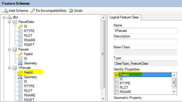
Look at the logical schema section and you'll notice a pattern:
- Feature Classes are denoted by the xs:complexType elements
- Identity Properties of the Feature Class are denoted by the xs:element element declared directly above the matching xs:complexType element.

If you look closely there is no
xs:element declaration for the
xs:complexType of our view:
So let's override this default logical schema by declaring an identity property for our view. The xml fragment follows this pattern:
<xs:element name="CLASS_NAME" type="CLASS_NAMEType" abstract="false" substitutiongroup="gml:_Feature">
<xs:key name="CLASS_NAMEKey">
<xs:selector xpath=".//CLASS_NAME" />
<xs:field xpath="IDENTITY_PROPERTY_NAME" />
</xs:key>
</xs:element>
Where CLASS_NAME is the FDO feature class name and IDENTITY_PROPERTY_NAME is the name of the identity property in the FDO feature class. We'll add one such fragment for
VParcels:

Now let's save it and load up another SQL Server connection to the same database. You'll notice that the express dialog has a field allowing you to specify an XML configuration file. We'll use our saved configuration file.

Now connect and take a look at
VParcels from the configured connection:

We now have identity properties for our view! Assuming we have an existing SQL Server feature source (without a configuration). Let's run a validation test on it, you'll get something like this:

Notice that MapGuide also can't get the identity properties for
VParcels (because it too uses FDO). Now let's edit the configuration of this feature source. In the feature source editor for Maestro, click
Edit Configuration Document and we'll get an XML editor, paste the contents of our XML configuration file in here and save it.

Now let's try validating again:

That problem is gone. We have now successfully applied a schema override! MapGuide can now read the identity properties from our view. Just to doubly make sure, let's see if we can make a selectable layer now. I'll make one themed by whether there are related records (black = has related record, red = no related record). Remember that our view is based off of a
left outer join so there may be parcels that have no related records.

Now let's house it in a map (switch on selectability) and preview it.

We now have a selectable view-based layer! Now having selectable views comes with a data modeling caveat:
We are only declaring these properties/columns to be unique to MapGuide. You have to ensure at the DBMS level (via constraints or other means) that the actual columns declared will be unique, otherwise selecting a feature
may not return the correct set of attributes that you were expecting!
Hopefully this better explains how you can use schema overrides to change how FDO/MapGuide looks at your data store. I'll eventually have some kind of visual editor for FDO Toolbox so you don't have to do any painstaking XML editing by hand.
On a side note, as I've demonstrated with this post FDO Toolbox is a very useful tool for diagnosing problems with MapGuide Feature Sources and other problems that may not be readily apparent through looking at error logs. Almost every time I do a (windows) deployment of MapGuide (Open or Enterprise) I'll always install a copy of FDO Toolbox (and Maestro) as well, because having something on hand to be able to look at your data is very useful.